Showing 10 items matching harp road -- kew east (vic.)
-
 Kew Historical Society Inc
Plan - Subdivision Plan, Violet Farm Estate, 1927
... harp road -- kew east (vic.)... grove -- kew (vic.) boorool road -- kew (vic.) harp road -- kew ...Pru Sanderson, in her groundbreaking ‘City of Kew Urban Conservation Study : Volume 2 - Development History’ (1988), summarised the periods of urban development and subdivisions of land in Kew. The periods that she identified included 1845-1880, 1880-1893, 1893-1921, 1921-1933, 1933-1943, and Post-War Development. These periods were selected as they represented periods of rapid growth or decline in urban development. An obvious starting point for Sanderson’s groupings involved population growth and the associated economic cycles. These cycles also highlighted urban expansion onto land that was predominantly rural, although in other cases it represented the decline and breakup of large estates. A number of the plans in the Kew Historical Society’s collection can also be found in other collections, such as those of the State Library of Victoria and the Boroondara Library Service. A number are however unique to the collection.The Kew Historical Society collection includes almost 100 subdivision plans pertaining to suburbs of the City of Melbourne. Most of these are of Kew, Kew East or Studley Park, although a smaller number are plans of Camberwell, Deepdene, Balwyn and Hawthorn. It is believed that the majority of the plans were gifted to the Society by persons connected with the real estate firm - J. R. Mathers and McMillan, 136 Cotham Road, Kew. The Plans in the collection are rarely in pristine form, being working plans on which the agent would write notes and record lots sold and the prices of these.The subdivision plans are historically significant examples of the growth of urban Melbourne from the beginning of the 20th Century up until the 1980s. A number of the plans are double-sided and often include a photograph on the reverse. A subdivision plan for nineteen ‘bonny, airy building blocks’ on either side of Violet Grove, Kew East. Violet Grove runs between High Street and Harp Road. Like many other subdivisions in Kew and East Kew, older houses (Lots 1 and 13) were often included in the subdivision. Such houses were in some instances the original properties that were subdivided, or in the case of the Violet Grove subdivision, new houses such as the weatherboard villa on lot 13. This villa is advertised as having a tiled roof, 5 rooms, panelled hall, double doors (Rooms 14 x 12 ft. 6 in. (2) 14 x 12, 12 x 11, 13 x 11). A bricked front verandah, a tiled stove recess and existing sewerage connection added to its saleable potential. Water, electric light and power, and gas were all offered as part of the deal. Violet Grove now has about 35 houses, which indicates that the 19 lots of the subdivision were to be further subdivided by purchasers. [A similar plan is in the Batten & Percy Collection of the State Library of Victoria.]subdivision plans - east kew, violet farm estate, violet grove -- kew (vic.), boorool road -- kew (vic.), harp road -- kew east (vic.) -
 Kew Historical Society Inc
Plan - Subdivision Plan, Flower Farm Estate, East Kew, 1922
... Harp Road -- Kew East (Vic.)... (Vic.) Harp Road -- Kew East (Vic.) Jas R Mathers Son ...Pru Sanderson, in her groundbreaking ‘City of Kew Urban Conservation Study : Volume 2 - Development History’ (1988), summarised the periods of urban development and subdivisions of land in Kew. The periods that she identified included 1845-1880, 1880-1893, 1893-1921, 1921-1933, 1933-1943, and Post-War Development. These periods were selected as they represented periods of rapid growth or decline in urban development. An obvious starting point for Sanderson’s groupings involved population growth and the associated economic cycles. These cycles also highlighted urban expansion onto land that was predominantly rural, although in other cases it represented the decline and breakup of large estates. A number of the plans in the Kew Historical Society’s collection can also be found in other collections, such as those of the State Library of Victoria and the Boroondara Library Service. A number are however unique to the collection.The Kew Historical Society collection includes almost 100 subdivision plans pertaining to suburbs of the City of Melbourne. Most of these are of Kew, Kew East or Studley Park, although a smaller number are plans of Camberwell, Deepdene, Balwyn and Hawthorn. It is believed that the majority of the plans were gifted to the Society by persons connected with the real estate firm - J. R. Mathers and McMillan, 136 Cotham Road, Kew. The Plans in the collection are rarely in pristine form, being working plans on which the agent would write notes and record lots sold and the prices of these. The subdivision plans are historically significant examples of the growth of urban Melbourne from the beginning of the 20th Century up until the 1980s. A number of the plans are double-sided and often include a photograph on the reverse. The subdivision called the ‘Flower Farm Estate’ in Kew East occurred in 1922. It included 61 lots on either side of Boorool Road between High Street and Harp Road. In an advertisement in The Argus in the same year, the proximity of the estate to the newly erected shops at the corner of Harp Road and High Street is noted. The Flower Farm Estate and similar subdivisions in Kew East were assisted by the extension of the High Street tramline in 1924.subdivision plans - east kew, flower farm estate, high street - kew east (vic.), boorool road -- kew east (vic.), harp road -- kew east (vic.) -
 Kew Historical Society Inc
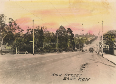
Postcard - High Street, East Kew, c.1927
High Street, Kew is the main Road in Kew. It was once also known as Bulleen Road, or Main Street. This section of the road is in Kew, although the narrow section on the right hand side of the photo is now Kew East. High Street progresses through a number of significant road junctions: beginning at Barkers Road; progressing through the intersection of Studley Park Road, Denmark Street and Princess Street at Kew Junction; branching left at the junction with Cotham Road; before reaching the junction with Valerie Street and Harp Road. It reaches its end at the junction of Burke Road, Kilby Road, Bulleen Road and High Street itself. An early photograph of this iconic Memorial that locates it in its context. Small, colorised real photo postcard of High Street, East Kew. Electric light poles line the road. Victoria Park is on the left and further on the horizon is the Boroondara General Cemetery.high street -- kew (vic.), victoria park, tram lines -- kew (vic.) -
 Kew Historical Society Inc
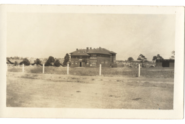
Postcard - Kew East State School No.3161, 35 Kitchener Street, c.1927
What is now Kew East Primary School was opened on its current site in Kitchener Street in 1923. The Kew East and Mont Albert Heritage Gap Study (August 2020) established that: 'Kew East Primary School No. 3136 is historically significant for the evidence it provides of an early phase in the development of Kew East which gathered momentum from the 1920s, as housing developed rapidly and the population increased in response to the extension of the High Street tram to Harp Road then Burke Road then improved tram connections between the area and the city.'A rare and early photograph of the school taken four years after its construction. Small, sepia coloured photographic positive of East Kew State School. The two storey red brick building was opened in 1923. This view, three years after its construction shows preliminary fencing and undeveloped playing grounds.schools -- kew east (vic.), government schools -- kew -- kew east, strathalbyn street -
 Kew Historical Society Inc
Clothing - Pale Blue Muslin, Silk, & Lace Dress, 1910-14
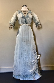
The dress was in the cupboard of Muriel Kerr, the donor's recently deceased mother. The donor remembers being shown it and trying it on in the late '70s or early '80s and being told that it belonged to her great-grandmother, Lilian Armstrong Ballantine (nee Power) [1887-1967]. Lilian Ballantine lived at 31 Harp Road (now the site of the Leo Baeck Centre) from the early 1920s to 1967. Lilian's married Archibald Dill Ballantine [1883-1947], in 1910. He was a member of the Monumental firm of A&G Ballantine, responsible for the Kew War Memorial (and possibly the Springthorpe Memorial). Lilian was highly involved with the Finlay McQueen Memorial Church [ie the East Kew Presbyterian Church]. Lilian's daughter, Mary (the donor's grandmother) married Alan McQueen, the son of Finlay McQueen, the first Minister of the East Kew Church. Mary Macqueen lived at 1 Oswin Street; she was a well-known artist. The dress is significant due to its associations with a family with strong connections, through a number of generations, to Kew East and its spiritual institutions. The garment's integrity and design also contribute to its aesthetic significance as a representative item of women's outerwear during the first decades of the twentieth century.Pale blue striped muslin single-piece dress with lace, tulle and embroidery at the neck and on the cuffs. The lace at the neck and cuffs is embroidered with coloured flowers, and edged with tulle. Bordering the v-neckline is a deeper blue guipure lace (possibly added later). There is a satin flower on the right side of the skirt which gathers the hem, exposing the deeper blue cotton underskirt. The dress has a narrow band of blue satin at the high waist. The cotton underskirt is attached by thread in places to the outer layer. Both the outer and under layers are attached with metal hooks and eyes. Edging the cuffs and hem of the dress is blue commercial fringing. The exterior of the dress has a slight brown tinge which is not apparent on the inside hem, suggesting that it has been discoloured through exposure. There are minor stains.women's clothing, edwardian dresses, lilian ballantine, australian fashion - 1910s, mary macqueen, finlay mcqueen memorial church, east kew presbyterian church, alan mcqueen, kew war memorial, archibald dill ballantine, leo baeck centre, 31 harp road -- kew (vic.), a&g ballantine, women's clothing -- 1900s, fashion - 1900s, fashion design -
 Kew Historical Society Inc
Postcard, Yarra Falls, The Yarra at Studley Park, 1920-1950
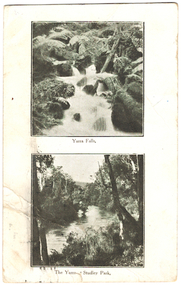
The Yarra River was a major subject for the producers of postcards in Melbourne. This dual image postcard shows images of the Yarra in two locations. Studley Park in Kew was a major location for recreation activities by the people of Melbourne.Image of the Yarra at Sudley Park shows remnant vegetation preserved on the banks of the Yarra in this part of Kew.Monochrome postcard with two images of the Yarra River, the lower image showing the Yarra at Studley Park. The reverse has a handwritten birthday greeting from Eileen to her mother Mrs Clark. Original postage stamp has been removed and slight tearing in top right corner. Two ink stamps KEW HISTORICAL SOCIETY have been added."Mrs Clark, Harp Road, East Kew / Wishing Mother a very happy Birthday and many returns / from Eileen"yarra falls, dual image postcards, yarra river -- studley park -- melbourne (vic.), monochrome postcards -
 Kew Historical Society Inc
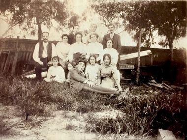
Photograph - Bennett Family Gathering, 22 Harp Road, c.1910
In 1980, Mr Laurie Bennett presented the Kew Historical Society with a number of photographs and postcards from the estate of his mother Eileen Mary Bennett (nee Clark). His mother was the daughter of Lawrence FH Clark(?-1946) and Mary Clark (?-1925) of 22 Harp Road, East Kew, in whose yard the photograph was taken. A year before the donation occurred a notice appeared in the Canberra Times stating that: "BENNETT, Eileen Mary. — May 8th at Tuross Heads, N.S.W. Late of 22 Harp Rd, East Kew, (Vic). Dearly loved wife of the late Harold Bennett, loved mother and mother in law of Laurie and Shirley (Melbourne), Kevin and Doreen (Canberra), grandmother of Linda, Stephen, Paul, Gabrielle, Peter, Mark and Jon."Part of a large collection of photographs and postcards in the collectionFamily portrait of members of the Bennett family of 22 Harp Road, East Kew. laurie bennett, eileen mary bennett, eileen mary clark -
 Kew Historical Society Inc
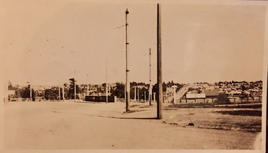
Photograph - High Street, Kew East, 1916
In 1980, Mr Laurie Bennett presented the Kew Historical Society with a number of photographs and postcards from the estate of his mother Eileen Mary Bennett (nee Clark). His mother was the daughter of Lawrence FH Clark(?-1946) and Mary Clark (?-1925) of 22 Harp Road, East Kew, in whose yard the photograph was taken. A year before the donation occurred a notice appeared in the Canberra Times stating that: "BENNETT, Eileen Mary. — May 8th at Tuross Heads, N.S.W. Late of 22 Harp Rd, East Kew, (Vic). Dearly loved wife of the late Harold Bennett, loved mother and mother in law of Laurie and Shirley (Melbourne), Kevin and Doreen (Canberra), grandmother of Linda, Stephen, Paul, Gabrielle, Peter, Mark and Jon."Part of a large collection of photographs and postcards in the collection. This dated photograph allows the researcher to identify development by 1916 in Kew and East Kew.High Street, Kew East in 1916 looking west. "High Street, East kew, near rail bridge."laurie bennett, eileen mary bennett, eileen mary clark -
 Kew Historical Society Inc
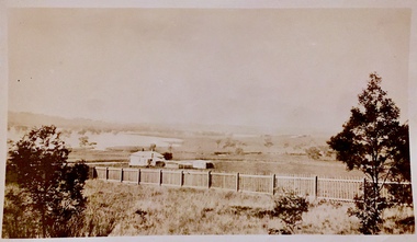
Photograph - Yarra in Flood - Belford & Kilby Farms, 1903
In 1980, Mr Laurie Bennett presented the Kew Historical Society with a number of photographs and postcards from the estate of his mother Eileen Mary Bennett (nee Clark). His mother was the daughter of Lawrence FH Clark(?-1946) and Mary Clark (?-1925) of 22 Harp Road, East Kew, in whose yard the photograph was taken. A year before the donation occurred a notice appeared in the Canberra Times stating that: "BENNETT, Eileen Mary. — May 8th at Tuross Heads, N.S.W. Late of 22 Harp Rd, East Kew, (Vic). Dearly loved wife of the late Harold Bennett, loved mother and mother in law of Laurie and Shirley (Melbourne), Kevin and Doreen (Canberra), grandmother of Linda, Stephen, Paul, Gabrielle, Peter, Mark and Jon."Part of a large collection of photographs and postcards in the collectionPanoramic photographic positive of North Kew where the Belford and Kilby Farms were located on the south side of the Yarra River. This photo, donated in 1980 by Laurie Bennett is the original of the two identical photos in the collection.laurie bennett, eileen mary bennett, eileen mary clark, floods -- yarra -- 1903 -
 Kew Historical Society Inc
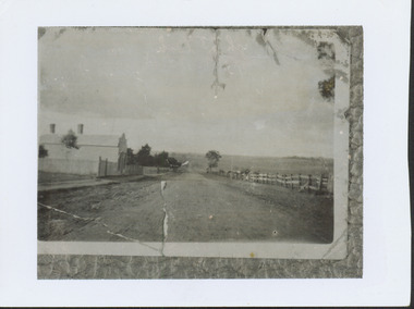
Photograph - High Street looking north to Burke Road, 1907-08
While a number of subdivisions of what was to become Kew East occurred in the 1880s, such as the 'Mount Pleasant Estate' (1888) and 'Monterey Estate' (1888), Glynn's Lot 91 remained open farmland until the Harp Estate (1912) was sold, hence the undeveloped nature of the view in 1907-8.A rare image of the open farmland in the eastern part of Kew looking towards Burke Road in 1907-8.Damaged, and very rare, black & white photograph of what was to become the suburb of East Kew, taken by a member of the Bennett family in 1907-8. The photograph is taken from the Harp of Erin Hotel showing, apart from a building on the left (no longer extant), fenced open farmland stretching into the far distance.HIGH ST LOOKING NOTRTH TO BURKE RD FROM HARP / EDWD GLYNN'S LOT 91 FROM 1851 / GIFT FROM BENNETT FAMILY 22 HARP RD EAST KEW 1980 / 1907-8harp of erin, high street -- east kew (vic), harp estate